
The list | Adelboden-Lenk: One of the most beautiful and diverse regions in the Swiss Alps
- The editorial team
- Sep 3, 2023
- 5 min read
The Adelboden-Lenk area in the Swiss Alps is a hiker's paradise.
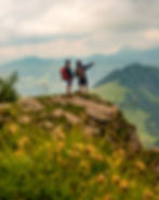
Whether a beginner or an expert, you will find plenty of trails to suit your taste and challenge your skills. Here are ten tips on hiking in the Adelboden-Lenk area.
Tip 1: Choose a hiking trail that suits your experience and fitness level.
The Adelboden-Lenk area has over 300 kilometres of hiking trails, ranging from easy to difficult and from short to long. You can consult the local tourist office for advice.
Tip 2: Check the weather forecast and the trail conditions before you start your hike.
The weather in the mountains can change quickly, and some trails may be closed or inaccessible due to snow, ice, or rockfall. You can find the latest weather and trail information on the Adelboden-Lenk website or at the cable car stations.
Tip 3: Wear appropriate clothing and footwear for hiking.
You should dress in layers that can be adjusted according to the temperature and the wind. You should also wear sturdy hiking boots with good grip and ankle support, and bring a hat, sunglasses, and sunscreen to protect yourself from the sun. A rain jacket and a warm sweater are also recommended, as it can get cold and wet at higher altitudes.
Tip 4: Pack enough food and water for your hike.
There are many restaurants and mountain huts along the hiking trails, where you can enjoy local specialities and refreshments. However, you should always carry some snacks and at least 1.5 litres of water per person, and refill your bottle at the springs or fountains you encounter on the way.
Tip 5: Respect the nature and the wildlife.
The Adelboden-Lenk area is home to many plants and animals that are protected or endangered, such as alpine flowers, marmots, ibexes, and eagles. You should not pick any flowers, feed any animals, or leave any litter behind. You should also keep a safe distance from the wildlife and avoid making loud noises or disturbing their habitats.

Tip 6: Follow the marked trails and signs.
The hiking trails in the Adelboden-Lenk area are well signposted with yellow, red-white, or blue-white markers, indicating the level of difficulty and the direction of the trail. You should always follow these markers and signs. This will ensure your safety and prevent erosion or damage to the environment.
Tip 7: Be prepared for emergencies.
Even if you are an experienced hiker, you may encounter unexpected situations or accidents on your hike. You should always carry a first aid kit, a whistle, a flashlight, a map, a compass, and a mobile phone. You should also inform someone of your itinerary and expected return time and call the emergency number 144 if you need help.
Tip 8: Enjoy the views and attractions along the way.
The Adelboden-Lenk area offers stunning scenery and varied terrain for hikers to enjoy. You can admire this region's majestic mountains, lush valleys, and charming villages on foot and discover some of its natural wonders and cultural heritage. Some of the highlights include:
The Engstligen Falls
The Engstligen Falls are the second-highest waterfalls in Switzerland, with a total drop of 370 metres in two stages. They are located near Adelboden in the Bernese Oberland and have been under preservation since 1948.

The Cholerenschlucht gorge
The Cholerenschlucht Gorge is a narrow and spectacular canyon carved by the Hünibach brook, which springs from a depression between Heiligenschwendi and Goldiwil villages. It flows for about 3 km until it reaches Stägacher village, where it plunges down 200 metres to the city of Thun and the Thun lake. The gorge can be explored on a wooden walkway that crosses lovely cascading waters and craggy cliffs. The walk takes about an hour and is suitable for families.

The Tschentenalp Panorama trail
The Tschentenalp panorama trail is scenic, with views of the Wildstrubel massif, the Engstligental, and the Simmental valley. It starts from the Sillerenbühl mountain station and leads to the Bergläger intermediate station, passing by the Tuftisee Lake and the Skynest viewpoint. The trail is 5.1 km long and takes about 1.5 hours to complete. It is not technically difficult and is accessible to all walkers. Along the way, there are ten varied activities and a barbecue site.
The Hahnenmoos Pass
The Hahnenmoos Pass is a historic crossing point between Adelboden and Lenk at an elevation of 1,950 m. It is the lowest pass between the Engstligental and the upper Simmental. The pass is traversed by a hiking track. The Berghotel Hahnenmoospass is a hotel and restaurant located at the summit of the pass and open in both summer and winter.

The Simmenfälle Falls
The Simmenfälle Falls are a series of cascades along the Simme River, which flows from Lenk to Wimmis near Spiez in the Bernese Oberland. The falls are located near Lenk, at the end of the valley, five kilometres behind the village. The water drops about 200 metres in several steps, forming a spectacular natural spectacle that can be enjoyed from various viewpoints.

The Betelberg marmot trail
The Betelberg marmot trail is a fun and educational trail for children and families, located on Betelberg Mountain near Lenk. The trail leads from the Leiterli top station to the Stoss midway station (3 km, approx. 1.5 hours.) Along the way, ten stations tell the story of Vogellisi, the girl who can talk to the birds, and her friend Karl-Joseph. There are also interactive elements, such as an eagle's nest, a wobbly bridge, a zip line and a maze with a barbecue area.
Tip 9: Take advantage of the cable cars and buses.
You can use cable cars or buses to reach some hiking trails or destinations in the Adelboden-Lenk area to save time or energy.
How to get here
The nearest airport to Adelboden-Lenk is Bern Airport, about 70 kilometres away. You can take a train from the airport to Frutigen and then a bus to Adelboden or Lenk.
Alternatively, you can fly to Zurich Airport or Geneva Airport, about 200 kilometres away. You can take a train from either airport to Spiez, another train to Frutigen, and then a bus to Adelboden or Lenk.
If you travel by car, you can take the A6 motorway from Bern or Zurich or the A9 motorway from Geneva and then follow the signs to Adelboden or Lenk.
Navigating the area
You can buy a hiking pass with unlimited access to 11 cable car destinations in Adelboden-Lenk for a fixed price.
You can also buy a Swiss Travel Pass that gives you unlimited access to public transport and cable cars in Switzerland for a fixed price. You can also benefit from discounts on museums, attractions and excursions.
You can find more information and tips on hiking in Adelboden-Lenk on the official website of Adelboden-Lenk.ch, where you can also book your accommodation, activities and events. You can also contact the tourist offices in Adelboden or Lenk for any questions or assistance.


