
The Ultimate Corsica–Sardinia Road Trip
- The editorial team

- Mar 30
- 19 min read

A complete Mediterranean loop. From mountain villages and sea-carved cliffs to turquoise bays and ancient stones
Twelve kilometres. That is all that separates two of the Mediterranean's most spectacular islands. On one side: Corsica. Mountains that drop straight into the sea. Cliff-top villages. Forests are thick with wild herbs. On the other: Sardinia. Ancient stone towers rising from the scrub. Beaches are so clear that the water looks photoshopped. The two are perfect for one of Europe's greatest road trips.
The route is simple. Start in Bastia in northern Corsica. Drive the island anti-clockwise, through the mountain capital where Corsican independence was born, past the most dramatic coastal road in the Mediterranean, through Napoleon's sun-baked birthplace, all the way to the white limestone cliffs of Bonifacio at the southern tip.
Then take the ferry. One hour across the Strait of Bonifacio and you are in Sardinia, and Italy, where the journey continues along the glittering Costa Smeralda, down the wild Gulf of Orosei coast, through the underrated capital Cagliari and on to Catalan-flavoured Alghero before the final crossing back to Corsica.
Eleven destinations. Two islands. One loop. Grab the steering wheel and step on it!
Corsica
Bastia — Corsica’s charismatic gateway

Most travellers arrive in Bastia by ferry from the mainland or by plane, and the city rewards an unhurried first night. Centuries of Genoese rule have left a deep imprint: the buildings around the old harbour are tall, narrow and painted in faded ochres and terracottas, the churches are richly baroque, and the general pace of life tilts unmistakably toward Italy.
The Vieux Port
Bastia’s old harbour is one of the most atmospheric places in Corsica. Colourful houses rise above a marina busy with fishing boats and leisure yachts, while café tables spill out along the quayside. Come for a morning coffee as the boats go out, or linger over an evening aperitivo as the light drops.
Terra Nova Citadel
The Genoese began building this hilltop fortress in the late 14th century, expanding it substantially through the 15th and 16th centuries, and walking through its narrow streets today still feels removed from the city below. Inside the Palais des Gouverneurs, the Bastia Museum covers the city’s history from its medieval origins to the present. The views across the Tyrrhenian Sea are outstanding.
Place Saint-Nicolas
One of the largest squares in France — wide, palm-lined, and built for the business of doing nothing in particular. Locals use it as their evening promenade, and weekend markets fill it with Corsican food, crafts and music. A good place to calibrate to island time before heading south.
Corsican Food Markets
The covered market near Place de l’Hôtel de Ville is the best introduction to Corsican food culture. Look for brocciu (a fresh sheep’s milk cheese unique to the island), wild boar charcuterie, honey from the maquis, and chestnut flour used in everything from bread to beer. The island’s AOC wines are worth seeking out too.
On the Road: Leave Bastia heading south along the island’s east coast — a relaxed drive past vineyards, fishing lagoons and long sandy beaches backed by eucalyptus trees. At Aléria, where the Romans once built their capital, turn west into the mountains toward Corte.
Corte — The soul of Corsica

The drive from the coast to Corte is one of Corsica’s great journeys: the road climbs steeply through chestnut and pine forests, the air cools, and the light changes from coastal brightness to something wilder and more dramatic. Corte itself sits on a rocky spur where two rivers converge beneath a ring of granite peaks. It served as the capital of the independent Corsican Republic under Pasquale Paoli from 1755 to 1769-
The Citadel and Musée de la Corse
The citadel crowns a sheer rock face above the town, its outline visible from miles away. The Musée de la Corse inside presents a thoughtful account of the island’s culture, crafts and pastoral traditions — the kind of museum that actually tells you something about a place rather than just displaying objects.
The Old Town Streets
Below the citadel, the Haute Ville’s narrow lanes and stepped passages are pleasantly free of tourist kitsch. Students from the university fill the cafés, and the mix of languages — Corsican, French, a little Italian — creates an atmosphere that feels genuinely lived-in.
The Restonica Valley
Drive or walk a few kilometres south of Corte into one of the island’s most beautiful gorges. In summer, locals swim in the clear rock pools of the Restonica river. Higher up, the trail continues to Lac de Melu, a glacial lake at around 1,710 metres, with views of the surrounding peaks. Allow half a day minimum.
GR20 Trailhead Access
The GR20 — 180 kilometres of mountain trail, widely considered the toughest long-distance walking route in Europe — passes through the mountains around Corte. You don’t need to walk the full distance to appreciate it: even short sections above the town reveal the extreme, beautiful landscape that makes this trail famous.
On the Road: Head west through the Niolo valley and down through chestnut forests toward the coast. The road to Calvi passes through the Balagne — Corsica’s garden region — with villages perched above olive groves and sea views appearing in gaps between the hills.
Calvi — A Genoese citadel, a deep bay, and a beach made for slowing down

Calvi is the kind of place that makes it difficult to stay on schedule. The town sits at the base of a massive Genoese citadel, facing west across a wide bay toward a mountain backdrop that turns pink at sunset. The beach stretches for several kilometres. The marina is animated but not hectic. Locals claim, with limited evidence but tremendous conviction, that Christopher Columbus was born here. Whether true or not, the boast gives the place a certain swagger.
Citadel of Calvi
The Genoese fortifications above the town are among the best-preserved in Corsica. The views from the ramparts take in the entire bay, the line of beach, and — on a clear day — the Italian coast. Within the walls, the streets are quieter and older-feeling than the town below: a good hour’s exploration.
Calvi Beach
The bay’s beach is one of the finest on the island: several kilometres of fine sand with the citadel silhouette at one end and mountains at the other. The water is reliably clear. Come in the morning before the sun becomes serious, or late afternoon when the light is best and the day-trippers have gone.
The Marina
The marina front is lined with restaurants serving freshly grilled seafood, langoustes and Corsican rosé. Evenings here are lively without tipping into noise. The marina is also the departure point for boat trips along the Balagne coast.
Balagne Coast by Boat
A half-day boat excursion from Calvi reveals a coastline that is largely inaccessible by road: secluded coves, dramatic limestone cliffs, sea caves and the red-tinged rocks that appear more intensely as you head south toward Porto. Snorkelling stops are usually included.
On the Road: The D81 south from Calvi toward Porto is among the most spectacular coastal roads in the Mediterranean. It hugs clifftops and plunges into gorges, with the sea visible almost constantly. Take it slowly: viewpoints are frequent, and the descent into Porto through the Calanques must not be rushed.
Porto and the Calanques de Piana — Where red granite meets the sea
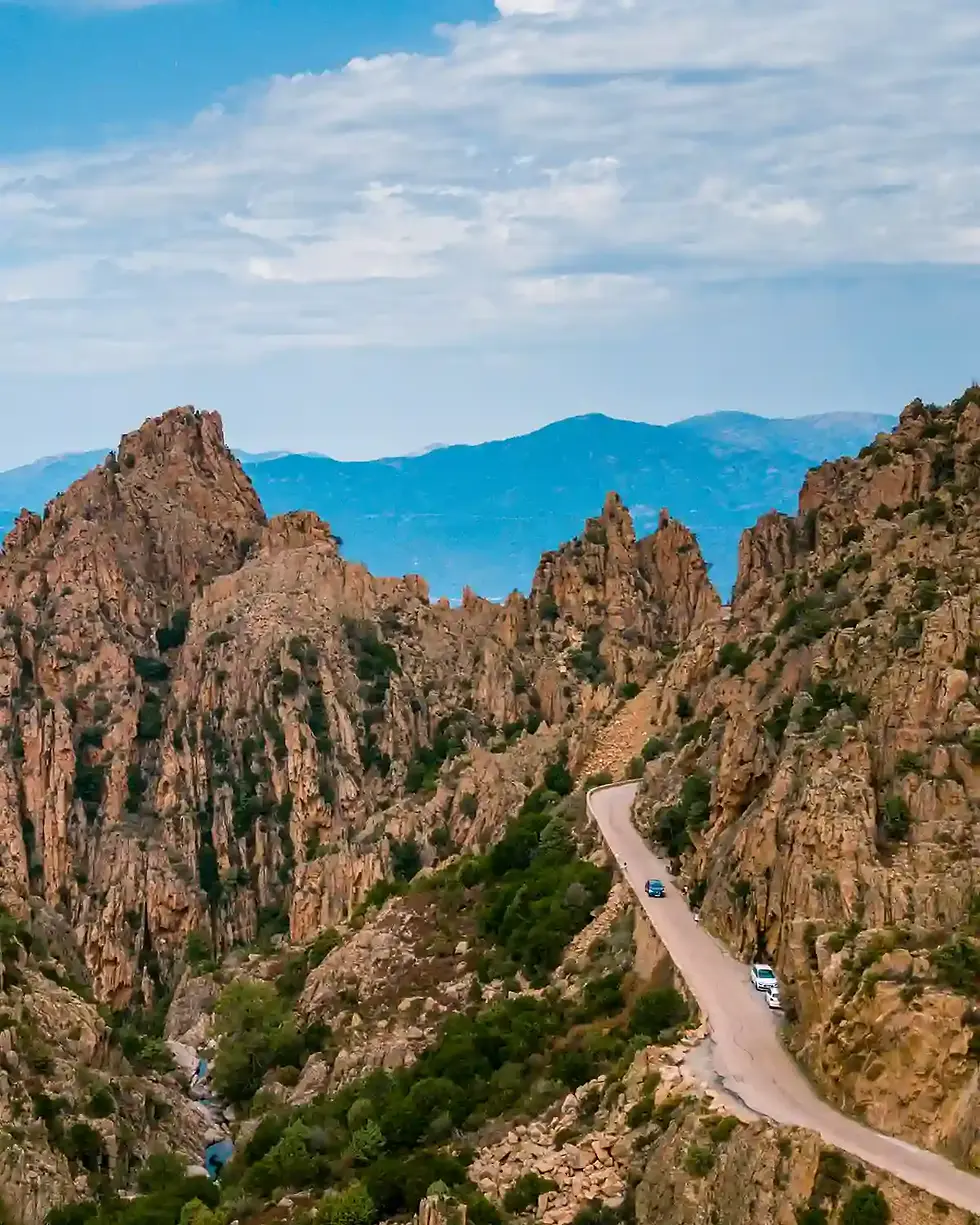
The Calanques de Piana are among the most startling things you will see from a car window anywhere in Europe. The road between Piana and Porto winds through a labyrinth of red and orange granite formations, towers, needles and arches sculpted over millions of years by wind and water, that drop directly into a gulf of improbably clear water.
The whole area, including the adjoining Scandola Nature Reserve, is a UNESCO World Heritage Site. Plan to spend at least half a day here, and ideally one night in Porto to catch the light at its most dramatic.
Drive the Calanques de Piana Road
The D81 through the Calanques offers multiple official viewpoints, but the most memorable moments tend to happen in between: a sudden glimpse of the gulf far below, a roadside rock formation shaped like a crouching animal, the way the granite glows in early-morning or late-afternoon light. Stop often.
The Village of Piana
Piana sits on a promontory above the gulf with one of the finest views in Corsica — an almost vertiginous panorama of red rock, dark forest and blue sea. The village itself is small and quiet, with a handful of good restaurants, a pleasant church, and the particular atmosphere of a place that knows it occupies an extraordinary location.
Scandola Nature Reserve by Boat
Accessible only by sea, Scandola protects a stretch of volcanic coastline unlike anything else in the western Mediterranean. Cliffs of red and purple rock rise from the water, pierced by caves and arches. The reserve is a sanctuary for ospreys, and the underwater zone — closed to divers and fishing — teems with marine life. Boat trips depart from Porto.
Swimming in the Gulf of Porto
Small beaches and rocky inlets dot the coastline around Porto, and the water is reliably clear and warm from June through September. The hamlet of Bussaglia, just north of Porto, has one of the better beaches in the area. At Porto itself, the old Genoese tower above the harbour is an easy walk and worth the climb.
On the Road: Continue south along the D81 and then the T20 toward Ajaccio. The road passes through the dramatic Gorges de Spelunca and the ancient village of Ota before descending toward Corsica’s capital. Allow two to three hours for the drive if you stop — and you should.
Ajaccio — Napoleon’s city

Ajaccio is Corsica’s capital and largest city, spread across a wide, south-facing bay that seems designed to catch every hour of available sunshine. The city wears its most famous son, Napoleon Bonaparte, born here on 15 August 1769, with an enthusiasm that borders on the theatrical. There are Napoleon museums, Napoleon streets, Napoleon café names, and a statue of Napoleon’s mother on the main waterfront. Behind the performance, however, Ajaccio is a genuinely pleasant city with good restaurants, a lively market and a working harbour atmosphere that its resort competitors further north cannot match.
Maison Bonaparte
Napoleon was born in this tall, somewhat austere house in the old quarter in August 1769 — less than a year after France acquired Corsica from the Genoese. The house is now a national museum, carefully restored and informative. The upper floors contain original family furniture; the lower rooms explain the broader context of Corsican history that shaped Napoleon’s early identity.
Ajaccio Cathedral
The 16th-century cathedral — built between 1577 and 1593 in a baroque-mannerist style — is where Napoleon was baptised on 21 July 1771. The interior contains notable works, including a painting attributed to Delacroix, as well as the original baptismal font, inscribed in Latin with the words Heic baptisatus Magnus Imperator. The cathedral also served as the Bonaparte family’s burial site before the later construction of the imperial chapel.
Ajaccio Food Market
Held in Place Foch each morning, Ajaccio’s covered market is one of the best in Corsica. Producers drive in from across the island to sell charcuterie, cheeses, honey, olive oil, herbs, fruit and vegetables. The brocciu here is excellent; so are the sausages made with figatellu, a cured liver sausage unique to Corsica.
The Sanguinaires Islands at Sunset
A short drive west of Ajaccio, the road along the Pointe de la Parata ends at a rocky headland facing a scattering of islets called the Sanguinaires — named for the blood-red colour they turn at dusk. The sunsets here are consistently spectacular. The writer Alphonse Daudet lived on the main island for a period; his Letters from My Windmill captures something of the atmosphere.
On the Road: The final stretch of Corsica follows the D196 and then the N196 south toward Bonifacio. The road passes through wild, scrubby coastal landscapes with occasional glimpses of offshore islands. The last section descends toward Bonifacio through a landscape that becomes noticeably flatter and drier — you are approaching the southern tip of the island, and the geology changes accordingly.
Bonifacio — The most dramatic town in the Mediterranean

The old town sits on a long, narrow promontory of white limestone, its buildings growing directly from the cliff edge, making it difficult to tell where the rock ends and the architecture begins. Below, sea caves and hidden coves cut into the base of the cliffs.
Across the strait, on clear days, you can see Sardinia. Bonifacio has been inhabited since at least the 9th century, and the layers of Genoese, Aragonese and Corsican history have accumulated into one of the most rewarding old towns in Europe.
The Medieval Citadel
The Haute Ville is a maze of narrow passages, old stone houses and sudden viewpoints over the strait. The Genoese loggia, the Church of Santa Maria Maggiore, and the dragon cistern — a vast medieval water reservoir carved into the rock — are all worth finding. The cliff-edge walk around the outer walls is breathtaking, particularly in the early morning before the crowds arrive.
Escalier du Roy d’Aragon
The staircase descends 187 steps (some sources cite 189, with the discrepancy attributed to two later additions) cut directly into the white limestone cliff face. Legend holds that the Aragonese carved it in a single night during their 1420 siege; in reality, it was built over a longer period, most likely by Franciscan monks seeking access to a freshwater well at the base of the cliff. The descent is steep, and the views are vertiginous. Not recommended in wet weather or for those with knee problems.
Sea Caves by Boat
Boat trips departing from the lower port reveal Bonifacio’s most extraordinary feature: a series of caves, arches and grottoes cut into the limestone base of the cliffs. The Grotte du Sdragonato — a cave with a hole in the ceiling shaped roughly like the map of Corsica — is a highlight. Half-hour and one-hour circuits are available.
Sunset over the Strait
Find a spot on the cliff-edge promenade or at one of the bars in the Haute Ville and watch the evening light move across the strait. On clear evenings, the hills of Sardinia are visible as a dark line on the southern horizon — and tomorrow, that is where you are going.
Ferry Crossing: Ferries depart from Bonifacio’s lower port to Santa Teresa Gallura in northern Sardinia. The crossing takes approximately one hour. Several operators run the route, including Moby Lines and Corsica Ferries; pre-booking is strongly advised in summer. You will want to be on deck for the departure — the view back toward the white cliffs of Bonifacio is one of the journey’s great moments.
Sardinia
Santa Teresa Gallura — Where Sardinia begins

Santa Teresa Gallura sits at Sardinia’s northern tip, a small town built around a central piazza and a long street descending to the port. The ferry from Bonifacio docks here, and the town makes an ideal first night: unhurried, local in character, with good seafood restaurants and one of the prettiest beaches in northern Sardinia within walking distance.
Rena Bianca Beach
This small, white-sand beach lies a short walk from the town centre, sheltered by rocky headlands and facing northwest across the strait toward Corsica. The water is shallow and very clear. Come early for the best light and a chance of having it relatively to yourself.
Capo Testa
A short drive west of Santa Teresa, this rocky peninsula is one of northern Sardinia’s stranger landscapes: vast rounded granite boulders eroded into surreal formations, hidden coves between the rocks, and views in every direction. The ancient Romans quarried granite here for columns used in buildings across the empire — look for the half-finished column shafts still lying where they were abandoned.
Torre di Longonsardo
A 16th-century Spanish watchtower on the headland above the town, one of hundreds of coastal watchtowers built around Sardinia during the period of Spanish rule. The view from its base encompasses the strait, the Corsican mountains on the northern horizon, and the coast stretching east toward the Costa Smeralda.
Piazza Vittorio Emanuele at Dusk
Santa Teresa’s main square fills with locals in the evening — families, older residents on benches, young people on scooters, everyone doing what Italian small-town squares exist for. Find a table at one of the bars and ease yourself into Sardinian time.
On the Road: Drive east along the SS133 and then south on the SS125 toward the Costa Smeralda. The road passes through a landscape of cork oak and scrub, with occasional glimpses of the sea to the east. The change in atmosphere as you approach Arzachena is palpable — the roads improve, the gardens become more manicured, and the cars become more expensive.
Costa Smeralda and Porto Cervo
Sardinia’s gilded coast

The water along this 20-kilometre stretch of northeastern Sardinia shifts between shades of green and turquoise that seem too vivid to be real. The beaches, Capriccioli, Liscia Ruja, Spiaggia del Principe, are white, fine and backed by granite headlands sculpted into shapes that took millions of years to perfect.
When Aga Khan, a visionary businessman, and his consortium arrived in the 1960s, they saw what this coastline could become. They turned a poor, undeveloped area into one of the Mediterranean's most exclusive and famous destinations, setting a new standard for luxury tourism. The summer crowd arrives by private jet. The yachts grow longer every year.
Porto Cervo Marina
The marina is one of the most spectacular in the Mediterranean — a deep natural inlet lined with yachts that seem to grow larger and more elaborate each year. The Piazzetta above the harbour is Porto Cervo’s social centre: cafés, boutiques and the particular entertainment of watching the promenade. Free and fascinating regardless of budget.
Spiaggia del Principe
Consistently ranked among Sardinia’s finest beaches, Spiaggia del Principe — the Prince’s Beach, said to have been the Aga Khan’s personal favourite — sits in a sheltered cove surrounded by sculpted granite and backed by fragrant macchia. The water shifts through shades of green and turquoise depending on depth and time of day. Arrive early in summer.
Scenic Coastal Drive
The secondary roads linking the beaches of the Costa Smeralda — Liscia Ruja, Romazzino, Cala di Volpe — reveal the coastline at its most varied and beautiful. Windows down, no schedule: this is a drive to be done slowly and without GPS insistence.
Sunset aperitivo in Porto Cervo
The ritual of the aperitivo is taken seriously along the Costa Smeralda. The bars on the Piazzetta and the terraces above the marina are best experienced at the hour the light turns golden — usually from around 7pm in summer. Order a Campari Spritz or a local Cannonau-based cocktail and consider that there are worse situations to be in.
On the Road: Head south and then east on the SS125 — the so-called Orientale Sarda — toward the Gulf of Orosei. The road passes through Nuoro province and enters the Supramonte, Sardinia’s great inland plateau of limestone and forest. The landscape grows more austere and more impressive as you descend toward the coast.
Gulf of Orosei and Cala Gonone
Sardinia’s wildest coast
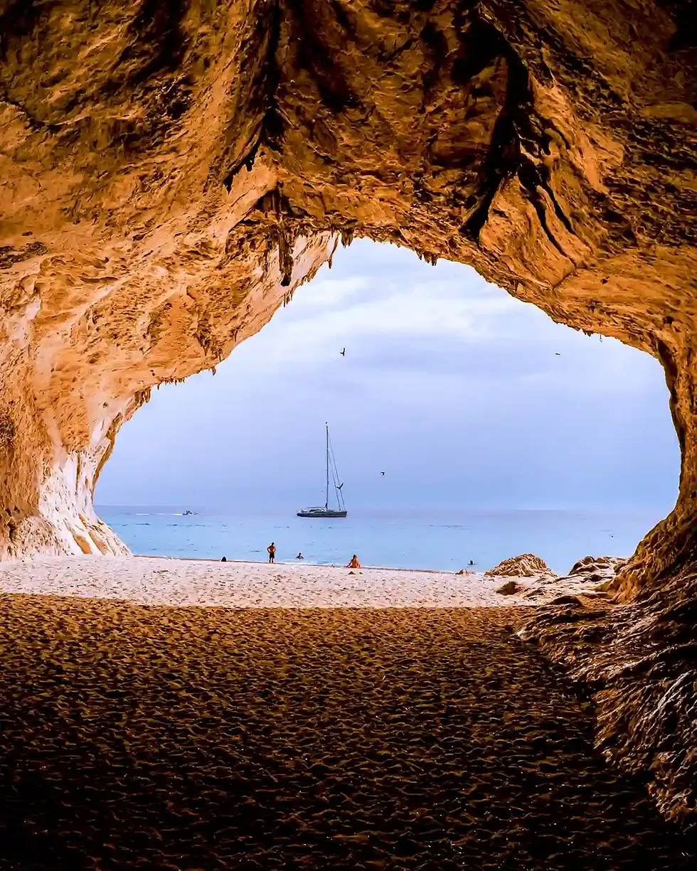
The Gulf of Orosei is where the Supramonte mountains meet the sea, and the collision is spectacular. Limestone cliffs hundreds of metres high drop directly into the water of impossible clarity.
The beaches at the base of these cliffs, Cala Luna, Cala Mariolu, and Cala Biriola, are among the finest in Europe, and almost all of them are accessible only by boat or by long, demanding hikes through the mountains.
The small town of Cala Gonone is the main base for the area: modest in itself, but positioned at the top of a hairpin road descending from Dorgali, with a marina and a good selection of boat-trip operators.
Boat Trip Along the Gulf
The essential experience of the Gulf of Orosei. Full-day excursions from Cala Gonone visit multiple beaches and the Grotto del Bue Marino — a sea cave with stalactites and stalagmites — with stops for swimming and snorkelling at the best coves. The boats know which beaches are least crowded at different times of day: trust their judgement.
Cala Luna
A crescent of pale pebble and sand backed by caves and tamarisk trees, with the limestone cliffs forming a dramatic backdrop on three sides. The water here is a deep, translucent blue-green. Accessible by boat from Cala Gonone or by a four-hour hike from Baunei — a route that passes through some of the most extraordinary canyon scenery in Sardinia.
Cala Mariolu
White and pale pink pebbles, water of extraordinary clarity, and a setting that has appeared in almost every photographic survey of European beaches. The snorkelling around the rocks at the edge of the cove is particularly good. Boat access only from Cala Gonone or Santa Maria Navarrese to the south.
Hike in the Supramonte
The mountains above Cala Gonone offer some of the most demanding and rewarding walking in Sardinia. The Gorropu Gorge — often cited as Europe’s deepest canyon — can be reached on a half-day walk from near Dorgali. Guided canyoning excursions into the gorge itself are available for those with more time and energy.
On the Road: Continue south on the SS125 along Sardinia’s eastern coast, past Tortolì and Arbatax — worth a detour for its famous red porphyry rocks at the port — and then southwest toward Cagliari. The final approach to Sardinia’s capital passes through the flat, lake-dotted coastal plain of the Campidano.
Cagliari — A capital with real depth

Cagliari is one of the most underrated capital cities in the Mediterranean. Built across a cluster of hills overlooking a wide southern bay, it has a depth of history. From Phoenician, Carthaginian, Roman and Pisan to Spanish and Italian. The Castello district, on the hilltop, feels more like a North African medina than an Italian city; the waterfront is resolutely modern; and the beaches at Poetto, just east of the centre, are used by locals year-round. Come for at least two nights.
Bastione di Saint Remy
This grand 19th-century terrace in the upper city offers the finest panorama in Cagliari: the bay, the salt lagoons (often pink with flamingos), the lower city’s rooftops, and the line of the Sardinian coast stretching east and west. The bastione connects the lower and upper cities via a monumental staircase that is as impressive as anything in southern Italy.
The Castello District
The medieval hilltop quarter is enclosed by Pisan towers and Aragonese walls, its streets narrow and often deserted outside the main tourist routes. The Cathedral of Santa Maria, partly Romanesque and partly baroque, houses a remarkable 13th-century pulpit. The Museo Archeologico Nazionale, just inside the walls, holds the finest collection of Bronze Age Nuragic bronzes in existence.
Poetto Beach
Eight kilometres of fine sand running east from the headland of Sella del Diavolo — the Devil’s Saddle — this is Cagliari’s city beach, used by everyone from children to elderly swimmers to triathlon athletes. The beach is backed by a long promenade of bars and restaurants. The salt lagoons behind Poetto are a flamingo habitat from spring through autumn.
Roman Amphitheatre
Carved into the limestone hillside below the Castello district in the 2nd century AD, the amphitheatre could hold up to 10,000 spectators. Most of the original seating is gone, quarried for later building projects, but the scale and setting remain impressive. The site is used for open-air concerts in summer.
On the Road: Head north from Cagliari on the SS131, Sardinia’s main north-south road — fast and functional but flanked by the nuraghi (Bronze Age stone towers) that appear throughout the island. Branch west toward Oristano and then north along the coast to Alghero, or cut through the interior via Sassari if time is short.
Alghero — Sardinia’s Catalan city
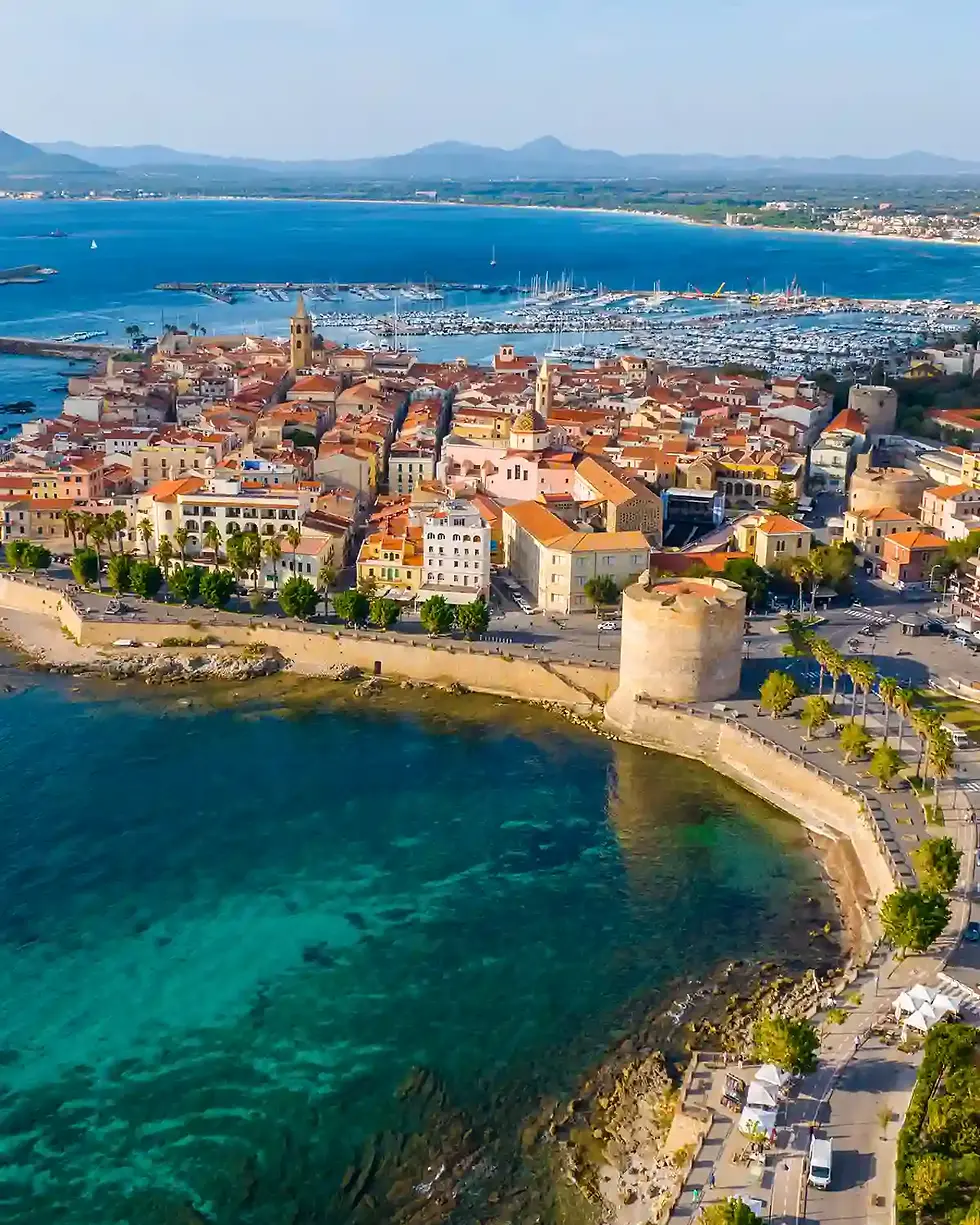
Alghero stands apart from the rest of Sardinia in a way that takes a moment to identify and then seems obvious: the street signs are in two languages, and the dialect spoken by some of the oldest residents bears no resemblance to Italian.
In 1354, Peter IV of Aragon besieged the city, expelled the Sardinian population, and repopulated it with Catalan settlers from Catalonia, Valencia and the Balearics. They stayed for centuries and left a linguistic and architectural legacy that persists to this day. The old town, enclosed by its sea walls, is one of the most beautiful in the Mediterranean. compact, well-preserved, and built for the business of living well.
The Sea Walls and Bastions
Alghero’s bastions are intact and walkable, making a circuit of the old town possible at sea level. The views from the walls at sunset — west across the bay, with the last light turning the water orange and gold — are among the finest in Sardinia. The walk around the complete circuit takes about forty minutes at a relaxed pace.
Neptune’s Grotto
The Grotta di Nettuno is a dramatic sea cave at the base of the Capo Caccia headland, about 30 kilometres from Alghero. The approach is either by boat from Alghero’s port (about one hour each way, recommended) or by descending the 656-step Escala del Cabirol staircase carved into the cliff face. Inside, the cave extends for several kilometres of stalactites, stalagmites and underground lakes — genuinely spectacular.
The Old Town Streets
The narrow lanes of the Alghero old town hold a mix of boutiques, wine bars, coral jewellery shops (Alghero’s red coral industry dates to the medieval period) and restaurants. The Cathedral of Santa Maria, begun in the 16th century in the Catalan Gothic style, is worth a visit for its carved stone details. The Via Carlo Alberto is the main evening promenade.
Aragosta alla Catalana
The signature dish of Alghero: lobster poached and served at room temperature with sliced onion, tomato, olive oil and lemon — a preparation unchanged since the Catalan settlers brought it. Several restaurants in the old town claim definitive versions. The lobster from the cold, clear waters off Capo Caccia is considered among the finest in the Mediterranean. Order it, eat slowly, and do not rush toward the ferry.
Completing the Loop
From Alghero, drive north to Santa Teresa Gallura, then take the ferry back across the Strait of Bonifacio to Bonifacio and head back to Bastia, completing a Mediterranean loop that few journeys in Europe can match.
Getting there, getting around, and crossing the strait
Renting a Car
The roads on both islands range from fast dual-carriageways along the coasts to narrow mountain roads where passing another vehicle requires patience. A compact car is strongly recommended over anything large.
Full insurance coverage is worth the extra cost. Corsican roads, in particular, are steep, winding, and unforgiving.
Rental cars are available at all major airports on both islands. Picking up in Bastia and dropping off in Alghero — or the reverse — is possible but typically incurs a significant one-way fee.
Driving on Corsica
Corsican roads demand full attention. The mountain routes between the coast and interior can involve continuous hairpin bends for twenty or thirty minutes at a stretch. Speed limits are low and sensibly so. Locals drive fast and know every corner — let them pass.
Fuel stations are less frequent once you leave the main towns. Fill up whenever the opportunity presents itself, particularly before heading into the interior. The D81 between Calvi and Porto, and the mountain road through the Restonica Valley, are among the most spectacular drives on the island, and among the ones that most require a focused driver.
Parking in old town centres such as Bonifacio and Corte can be tight. Most historic centres have paid parking areas just outside the old walls.
Driving on Sardinia
Sardinia's road network is generally wider and more forgiving than Corsica's, though the SS125 Orientale Sarda along the eastern coast has its own dramatic sections. The SS131, the island's main north-south artery, is fast and efficient for covering distance. Off the main routes, particularly around the Gulf of Orosei and the Supramonte, roads narrow considerably.
Sardinia is larger than it looks on a map. The distances between stops can take significantly longer than expected, once you factor in terrain and road quality. Build extra time into every leg of the journey.
The Ferry Crossing
The Bonifacio–Santa Teresa Gallura crossing is the heart of the route, a one-hour passage across the Strait of Bonifacio that connects the two islands. The main operators are Moby Lines and Corsica Ferries, both of which run multiple crossings daily during the summer season.
Book in advance. The crossing is popular throughout the summer, and last-minute vehicle spaces can be difficult to find in July and August. Foot passengers have more flexibility, but drivers should secure a reservation before arriving at the port.
The crossing itself is straightforward and usually calm, though the strait can be choppy when the wind is up. Go up on deck regardless: the departure from Bonifacio, with the white cliffs receding behind the boat, and the arrival into Santa Teresa with the Sardinian coast coming into focus, are two of the better moments of the entire journey.
When to Go
May, June and September, October are the ideal months for this route. The weather is warm and reliable, the roads are manageable, and the best beaches are busy but not impossible to reach. July and August bring intense heat, heavy traffic on the coastal roads, and beaches that can feel overwhelmed at peak hours. The ferry crossing and most popular beaches are at their most crowded in the first two weeks of August.
October is quieter and often still warm enough for swimming, though some boat services to the more remote beaches wind down by mid-month.


