


Blue Water to Grand Canyon: Driving the Côte d’Azur


Start in Nice, follow the Corniches past Monaco, then turn north into Provence and finish at the rim of the spectacular Gorges du Verdon. Along the way: medieval villages, turquoise water and the lavender fields of Valensole.
The Côte d’Azur is extraordinary. The light on the water at Cap Ferrat, the Corniche roads above Monaco, the evening promenade in Nice’s old town — these things justify the reputation that has been accumulating since the Victorian aristocrats discovered the Riviera in the 1860s and decided, collectively, that the Mediterranean winter was superior to the English one. They were right, and the infrastructure that followed their decision — the grand hotels, the casino at Monte Carlo, the Belle Époque villas — remains largely intact and still worth seeing.
By late summer and into autumn, peak-season crowds have eased, the worst of the heat is gone, and the light softens. The sea is still warm, and the roads are easier to enjoy.
From Nice, the route follows the coast towards Monaco before leaving the Mediterranean behind and heading into Provence. Within a short drive, the landscape begins to change. Further inland, the crowds thin, the limestone mountains take over, and eventually the road reaches the rim of the Gorges du Verdon.
Allow four days. Drive the coast slowly, then leave it and drive the interior even more slowly. The two halves of this trip are so different that the contrast becomes part of the experience.
The starting point — Nice
The city that invented the seaside holiday, and has been refining it since

Nice is the capital of the French Riviera and the city that gave its name to Europe’s most famous promenade — the Promenade des Anglais, created in the early 1820s with funding from Nice’s British community. The English are less visible now, but the promenade remains the city’s spine and the best place to understand what Nice is: a Mediterranean city that takes its pleasures seriously, with a pebble beach it is vaguely embarrassed about and an old town among the finest in southern France.
The Vieux-Nice — the old town, east of the Place Masséna — is Italian in character, which makes historical sense: Nice was part of the Kingdom of Sardinia until 1860 and retains the narrow streets, baroque churches, and food traditions of Liguria across the border. The Cours Saleya market, with its flowers, vegetables, olives and local specialities, is one of the places that gives the old town its particular character.
The Musée Matisse, housed in the 17th-century Villa des Arènes, a Genoese-style villa above the city, holds one of the world’s largest collections devoted to Matisse. He lived and worked in Nice for much of the latter part of his life, and the Mediterranean light and landscape became central to his work. Nearby, the Musée National Marc Chagall provides another major art stop.
For the classic view over Nice, climb Castle Hill above the old town. From the park, the Baie des Anges stretches west towards the airport while the rooftops of Vieux-Nice fill the foreground.
Stop 1 — The Three Corniches
Three roads, three versions of the same coast

You can choose three parallel roads at different altitudes that serve the stretch of coast between Nice and Monaco. Each gives its own take on the same section of Riviera.
The Basse Corniche — the RM 6098, running close to sea level — passes through Villefranche-sur-Mer, around Cap Ferrat, Beaulieu-sur-Mer, and Èze-sur-Mer. This is the Riviera at its most concentrated: the deep natural harbour at Villefranche, the Cap Ferrat peninsula, and the Villa Ephrussi de Rothschild in its gardens above the sea.
In Beaulieu you find the Villa Kérylos, built between 1902 and 1908 as a contemporary reinterpretation of a Hellenistic Greek villa. The house was designed to recreate the atmosphere and architecture of ancient Greece while incorporating the comforts and technology of the early 20th century.
The Moyenne Corniche — the RM 6007, at mid-altitude — passes through Èze village, a medieval perched settlement at 429 metres with a cactus garden at its summit and views that have long drawn visitors. Friedrich Nietzsche regularly climbed the steep path from the coast while working on Thus Spoke Zarathustra. The path is now known as the Nietzsche Trail.
The Grande Corniche — the RM 2564 — follows roughly the route of the ancient Via Julia Augusta, the Roman road to Italy. The views from here take in the full sweep of the coastline towards the Italian border, and the road passes through La Turbie, where the Trophée d’Auguste — a Roman victory monument built in 6 BC — stands above the coast.
Stop 2 — Monaco
The city-state that takes excess seriously

Monaco is 2.02 square kilometres — the second-smallest sovereign state in the world — and it includes a Formula One circuit. The casino has operated since 1863, and the principality includes a palace, an oceanographic museum founded by Prince Albert I, a harbour full of superyachts, and a population in the tens of thousands. More than 40 percent of residents are millionaires.
The Circuit de Monaco runs through the streets of the principality—the same streets residents use daily, temporarily closed for the Grand Prix each May. Walking the circuit gives a sense of the scale of the racing that television does not convey. The Fairmont Hairpin, the tunnel and the chicane at the swimming pool complex are all recognisable landmarks to anyone who has watched Formula One.
The Musée Océanographique, perched on the cliff above the sea, was directed by Jacques Cousteau for 32 years and remains both a spectacular aquarium and a serious scientific institution. Prince Albert I commissioned the building, which opened in 1910.
The Casino de Monte-Carlo remains one of Monaco’s most renowned landmarks. Visitors can enter the atrium without paying, while access to the gaming rooms requires a ticket and appropriate dress.
Stop 3 — Leaving the Coast: Into Provence
The turn north that changes everything

Leaving the he waterfront can be hard, but nevertheless, turn north from Nice or Antibes on the A8 or D6202, and within a short drive the Riviera is behind you, and Provence begins.
The change is immediate. The stone changes colour from the coast's warm ochre to the grey-white limestone of the pre-Alps. The vegetation changes from Mediterranean maquis and palm trees to scrub oak and lavender. The traffic thins. The villages — Gourdon, clinging to a cliff above the Loup gorge; Tourrettes-sur-Loup, an almost perfectly preserved medieval village around its central square; Saint-Paul-de-Vence, the artist’s village associated with Chagall, Léger and Matisse — offer a very different atmosphere from the coastal resorts.
The roads north from Grasse, the historic perfume capital of France, continue through increasingly austere limestone landscape towards the Verdon plateau.
In Saint-Paul-de-Vence, the Fondation Maeght is one of Europe's major modern art foundations. Designed by Josep Lluís Sert, the complex incorporates works by artists including Miró, Giacometti, Braque and Calder into its architecture and gardens.
For a first taste of the landscape that lies ahead, the D3 through the Loup gorge north of Grasse provides a dramatic introduction to the limestone country.
Stop 4 — Moustiers-Sainte-Marie
The village with a star and a ceramics tradition

Moustiers-Sainte-Marie sits at the entrance to the Gorges du Verdon, tucked into a cleft in the limestone cliff with a waterfall running through the village and a star hanging on a chain high above the main street. The star hangs roughly 227 metres above the village. According to local legend, a knight placed it there after returning from the Crusades, thanking the village for his safe return. Its exact origins remain unknown.
The village is Provence's ceramics capital. Its faïence tradition took off in the 17th century, when Pierre Clérissy learned the secrets of white enamel from an Italian monk. The workshops and galleries lining the village streets preserve the tradition, producing everything from tourist pieces to serious collector ceramics. Traditional Moustiers faïence is particularly associated with white ground and blue decoration, although other colours became common in later traditions.
Above the village, the chapel of Notre-Dame de Beauvoir is reached by a steep climb of several hundred steps. The path leads to views over the rooftops of Moustiers and the landscape beyond.
Moustiers is also one of the most convenient bases for exploring the Gorges du Verdon, sitting close to the canyon's western entrance.
Stop 5 — The Gorges du Verdon
Europe’s grand canyon, from both rims

The Gorges du Verdon formed over millions of years as the Verdon River cut through the limestone plateau of Haute-Provence. The result is a canyon around 25 kilometres long, with cliffs reaching up to 700 metres above the river. It is widely regarded as Europe’s largest canyon and is one of the most dramatic landscapes in France.
The canyon is accessible from two rim roads: the Route des Crêtes on the north bank and the Corniche Sublime on the south bank. Both offer spectacular views into the gorge.
The Route des Crêtes is a roughly 24-kilometre loop along the canyon rim, with a series of belvederes offering increasingly dramatic views into the gorge. Some viewpoints provide more than 700 metres of open space between the road and the canyon floor.
The Corniche Sublime on the south bank has a series of viewpoints, including the Balcons de la Mescla where the Artuby torrent joins the Verdon in a dramatic confluence visible from the road above.
The river at the bottom of the canyon is famous because of its striking turquoise colour, a defining feature of the Verdon landscape.
The Route des Crêtes is seasonal, and sections of the circuit are one-way. Conditions can change with weather, so checking the current situation before driving is essential.
Stop 6 — Lac de Sainte-Croix
The reservoir that became a landscape
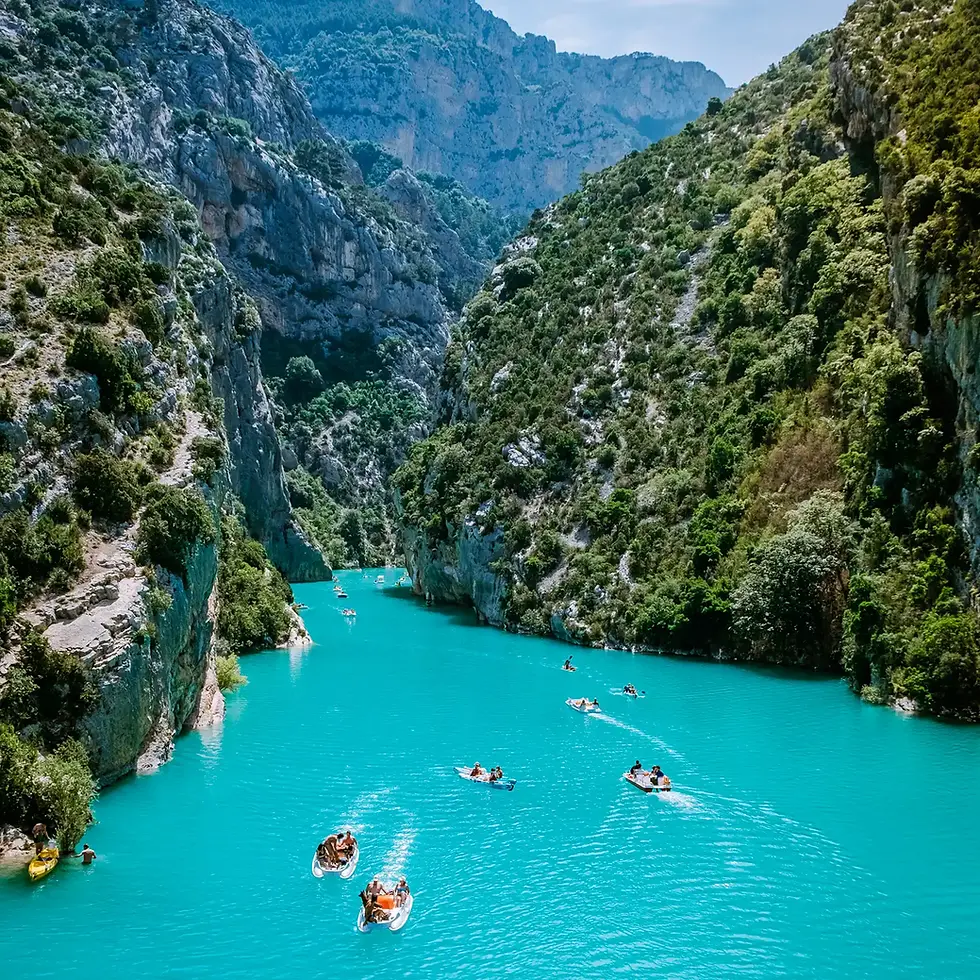
The Lac de Sainte-Croix was created with the construction of the Sainte-Croix dam, and the reservoir was filled in 1973–74. The project flooded the former village of Les Salles-sur-Verdon, which was subsequently rebuilt higher up the hillside.
The reservoir stretches for around 10 kilometres and has become both an important water resource for the region and a major recreational lake for swimming, sailing, kayaking and pedal-boat hire.
At the entrance to the Gorges du Verdon, pedal boats and electric boats offer a different perspective on the landscape. From the water, the canyon walls rise on either side before the narrow entrance opens into the broad expanse of the lake.
Les Salles-sur-Verdon, rebuilt above the lake after the former village was flooded, makes a natural stopping point before continuing towards the Valensole plateau.
Stop 7 — The Valensole Plateau and the Return South
From lavender country to the road back to the coast

The Valensole plateau stretches north and west of the Gorges du Verdon in a broad agricultural plain at around 500 metres altitude. It is best known for its lavender fields, which draw visitors in early and mid-summer when the plateau turns purple. By September, much of the lavender has been harvested, leaving a quieter agricultural scene of fields, oak and open horizons.
This is not necessarily a reason to skip Valensole. The summer crowds have eased, the temperatures are more comfortable, and the plateau offers a different experience once the lavender spectacle is over. The exact appearance of the fields varies from year to year and from one part of the plateau to another.
The village of Valensole is functional and unpretentious, with a market and shops selling local lavender products. Riez, around 10 kilometres north, has a Roman baptistery from the 5th century and a market-town character that has remained largely unchanged for centuries.
The return south to Nice via the D952 and D955 follows the Verdon River downstream towards Castellane, then takes the Route Napoléon — the N85 — back towards Grasse. Today's Route Napoléon follows substantial sections of the route associated with Napoleon's return from Elba in 1815, although the modern road is not identical to the historical route.
The route ends much as it began: among the limestone mountains before descending once again towards the Mediterranean.
Practical Information
Getting there:
Fly to Nice Côte d’Azur (NCE), the region’s main international airport with direct connections from across Europe and North America. You can hire a car at the airport. Alternatively, arrive by train: Nice has direct high-speed services from Paris and rail connections with cities including Milan and Geneva.
Car hire:
A normal-sized car is sufficient for the route, but smaller cars are more comfortable on the narrowest mountain and Corniche roads. Avoid unnecessarily large vehicles.
When to go:
Late summer and early autumn are especially inviting for this road trip. September offers warm coastal weather, quieter roads and good conditions for exploring the interior. October can bring cooler temperatures and changing mountain conditions, but the lower elevations around Nice remain relatively mild. If lavender is the main reason for travelling, however, plan the trip for the flowering season in early and mid-summer.
Length and time:
Nice to the Gorges du Verdon and back, including the route’s major detours, is best regarded as a road trip of several hundred kilometres rather than a simple point-to-point drive. Allow four days minimum — two on the coast and two around the plateau and canyon.
Practical notes:
Monaco requires paid parking — use one of the city’s public car parks and walk into the centre. The Route des Crêtes is seasonal, and sections of the circuit are one-way; check current road conditions before setting out.
For the Blanc-Martel hike, check current trail conditions and shuttle availability before setting out. In 2026, part of the trail has been temporarily rerouted following a rockfall.
If visiting the lavender fields, stay on the paths between the rows, don't trample plants, and remember that many of the most photographed fields are private property.


